PrintLims Lims development Maps Mapserver Flash Webmapping and GIS
Maps and GIS
This section will guide Member States and LIMS users on how to present some interactive maps (national and regional) using LIMS data.
Everybody knows about reading a map on line like on google maps (have a glance to this example of Google Maps Botswana and its capital Gaborone where SADC HQ stays)
This part of the LIMS web site will guide you on to create your own "online maps" to be posted on this collaborative portal or on your respective national portals.
Interactive Mapping
The interactive maps should display the various aspects of the livestock sector in the SADC member states (animal production, livestock development, marketing and trade, animal health), taking national and regional perspectives.
Member States are encouraged to use their own data and to add thematic maps to their national reports. They may also request from SADC the use of the Geoclip software acquired by SADC, to be used at national level in order to publish Geoclips Web maps. These maps will be then uploaded and posted on the LIMS portal because of licensing agreement (sadc.int domain only).
Geoclip screen
Thematic maps
To produce thematic maps , firstly read the following guiding document:
It will help to make you more "map aware".
Secondly, query your LIMS database and use the result of the query to establish a link between the data and the geographical layers you have collected. the geographic layers should reproduce the same geographical partitions as implemented into LIMS, be they administrative partitions or technical partitions (livestock management zones).
Map layers
A good open source of map layers (Administrative boundaries) is Maplibrary.
Free GIS Software's
To map your data using geographical layers and LIMS data, you can use various free softwares like the freeware from ESRI, "ArcExplorer " (make sure you also have Java installed on your computer), which you can download here.
It has a full documentation attached.
For the non english speaking SADC countries (french and portuguese speaking), one can use a mapping software like Philcarto to make maps (a software which can be run in the three SADC languages). It has tools to convert shape files (ESRI standads) into Adobe Illustrator files format (.ai) as used in the software (you do not need to have Adobe though).
PRINT has published two simple leaflets in portuguese to demonstrate the use of ArcExplorer and Philcarto.
SADC has purchased a license for Geoclip to produce Flash-based maps to be posted on line. For more information visit the Geoclip website.
Web Mapping Service
Moreover, a webmapping service (using Mapserver software), has been developped as a common mapping tool under the AIMS portal. It is compliant with the WMS standard (Web Mapping Services) and therefore follows the OGC recommendations. There, you can overlay data and layers from various OGC compliant sources (FAO, Google maps..).
GPS and coordinate systems

Conversion of a spherical coordinate system to another coordinate system
Concerning the use of GPS, PRINT has published a guide on how to use GPS, extract and use data in combination with the Mapsource software (Garmin) and with the Track for Africa database (a collaborative mapping initiative to document infrastructures in Africa, and particularily rich for the SADC region).
GPS set up
Before marking any way point (before marking a location), set the GPS parameters to the appropriate coordinate system. WGS84 is the most universal but you could use another one UTM for instance.
Garmin
Refer to your GPS manual if you are equipped with Garmin. You can also use Mapsource© a Garmin software which support import of GPS data and can therefore convert them after they have been imported, by changing the setting of the coordinate system in the preferences menu of the application.
On line free conversion (Internet connection required)
You can access a free on line application here:
Free coordinate converters
You can access free applications here
An example of menus you will get with them (here Geotrans)
Menu to convert coordinates
Conversion in GIS software’s
Users of ArcGis and Mapinfo must see the relevant sections of the application manuals
Commercial conversion software’s:
Just google them !
Some examples of National and Regional Maps with GeoClip
Geoclip manual:
Launch the demo & test map of SADC region with a historical compilation of suspected outbreaks of CBPP and other diseases in the region
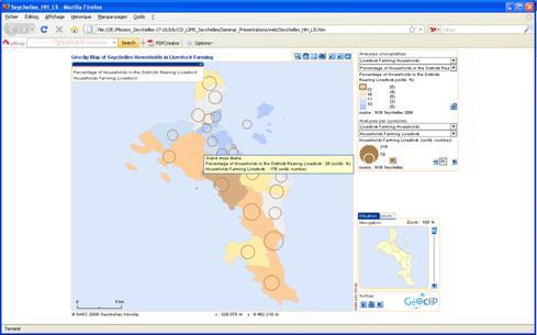
Distribution of Households involved in Livestock Farming in the Seychelles (Mahe island), made during the LIMS situation analysis in Seychelles
© SADC 2009 - All rights reserved - Disclaimer stating